Culture and history › Heritage
 ST.PETER`S CHURCH
 ETHNO HOUSE "MARASOVIĆ"
 HILL FORTS AND BURIAL MOUNDS
 CISTERNS AND WELLS
 KROV NA KUBU
 MIRILA
 VEČKA TOWER
 ARGYRUNTUM
ST.PETER`S CHURCH
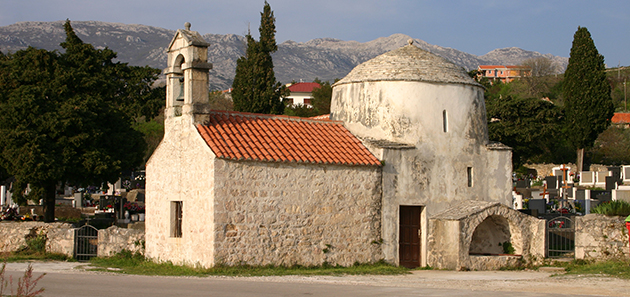
This medieval church is located on the Adriatic highway between Starigrad and Seline. In the vicinity of the church, there is a graveyard with burial sites dating back to the mid 13th century. There are preserved, distinct gravestones in the shape of massive rock slabs decorated with simple, shallow relief depictions, dating back to the 14th-16th centuries. The church was constructed in the pre-Romanesque Early Croatian style, most likely during the turn of the 10th century. There is a small structure next to the church, believed to have been used as a baptistery. “Gathered from the fragments, it is clear that the church was constructed by a philanthropist as a votive gift, as is the case with the construction of churches and chapels in the Early Croatian times” - Rukavina, A.: Zvona ispod zvijezda (Bell under the stars), Ličke župe (Lika parish), Gospić, 1984. In recent years, archaeological research has been conducted at the church and now it is fully recovered.
In addition to the Church of St. Peter, there are several medieval monuments worth visiting in the region:
Osim crkve Sv.Petra, na širem se području nalazi još nekoliko srednjovjekovnih spomenika vrijednih posjeta:
- the Holy Trinity fortress, located approximately 6 km west of Starigrad-Paklenica, near the towns of Tribanj-Šibuljine – one of the largest fortresses known from Mljet to Istria, dating back to the 6th century;
- a late Classical military fortress located over the town of Modrič, in the position of a gradina (hill-fortress);
- the Paklarić fortress, located in close proximity to Paklenica National Park, 100 metres above sea level; there is a well-maintained educational trail leading towards that offers a beautiful view over the entire Podvelebit Channel;
- the Church of St. George in Rovanjska, a town located approximately 10 km from Starigrad-Paklenica.


ETHNO HOUSE "MARASOVIĆ"
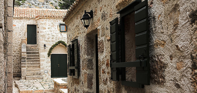
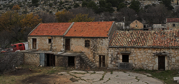
Ethno-house Marasović is located in hamlet Marasovići, close to the entrance in the National Park Paklenica in Starigrad-Paklenica.
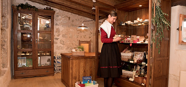
In authentic atmosphere of this stone house you will find traditional food of the area and permanent exhibition Mirila – unique custom from the past, today protected intangible cultural heritage of the Republic of Croatia.
The house is open for visitors from May to October.


HILL FORTS AND BURIAL MOUNDS
Defensive fortifications of drystone (stone walls without mortar or other binding material) known as GRADINE (hill forts) were built in the Bronze and Iron Ages on rocky hilltops and prominent Velebit ridges.
They served as shelter for the populations of the surrounding hamlets when danger threatened, while some may have been permanent residences inhabited by powerful locals. Today they are in ruins, but in places one can still make out ring-shaped embankments up to several metres high in places.
For example, a hill named Gradina (a Croatian word for “hillfort”) rises some fifty meters above the western side of Modrič cove. The archaeological site on its top was occupied during the late prehistory and the Late Roman period.
Remains of circular ramparts run around the flat summit of Gradina. They enclose and protect an area of about 2,5 hectares that used to be occupied by a prehistoric settlement. Judging by the finds collected from its surface, the settlement probably dates from the Iron Age (1st millennium B.C.), when autochthonous Liburnians, known for their maritime traditions, dominated this region.
Remains of the Late Roman fortification at Gradina still stand almost two meters high at a few places. Its ramparts and the adjoining square towers were built of stone bound with mortar. They enclose an irregular rectangle 70 meters wide, extending for some 160 meters in the east-west direction.
A roughly contemporaneous fortress of a similar type is located 15 kilometers to the west, at Sveta Trojica near Tribanj. They were built to protect shipping that passed through Velebit Channel, and to provide protection and refuge to the local population.
In the direct vicinity of the hill forts there are often BURIAL MOUNDS – heaps of large round stones under which powerful individuals of the time were buried in burial chests made of stone slabs. Most have been dug up and their graves plundered, but they can still be discerned in places, like in the area of the hamlet of Ljubotić above Tribanj-Kruščica.


CISTERNS AND WELLS
Before the construction of waterworks, potable water was scarce in the villages of Velebit’s maritime slope. Rare springs are located in higher mountain reaches, while permanent watercourses are virtually nonexistent due to the permeability of the karstic terrane. Violent storms can produce raging torrents, but they will flow for just a few hours. Ample quantity of rain falls from autumn to spring, but there is a long draught in summer. Rainwater therefore had to be captured before it disappeared in karstic underground, and stored for the dry season.
Wells and cisterns were built for storage of the precious water. In the late 19th and early 20th century, Austro- Hungarian authorities strived to improve water supply in Dalmatia by building large cisterns. Public cisterns in Starigrad-Paklenica, Seline, and Tribanj were built at that time. They were constructed in modest neoclassical style, characterized by simple, plain shapes, flanked by stone basins for laundry and watering animals.
Many households, especially those in hamlets high up the mountain, did not have their own cisterns, so they had to struggle in various ways in order to obtain the precious potable water. People obtained water using natural sources called kamenice, ledenice, čatrnje, lokve, špilje, vrulje...
More about cultural and historical heritage that speaks of millennia of human existence on the slopes of Velebit despite harsh living conditions and scarcity of water brings „The Velebit`s story about water“.
The tourist map „The Velebit`s story about water“ is availible in tourist information centers Starigrad, Seline and Tribanj.
We suggest you to visit:
STARIGRAD-PAKLENICA
A wooden vessel called burilo, used by women to carry water from cisterns, or snow from the mountain, is on display at the ethno-house Marasović, in the hamlet of Marasovići near the entrance to the National Park Paklenica. Near by, an old water mill has been restored.
2 wells in the street named Put bunara(„Path of wells“), public cistern built by Austro-Hungarian authorities.
SELINE
There is an old well near the center of Seline, in the street named Put bunarića ("Little Well Road"), built in traditional drystone technique. Local inhabitants still use the water that collects in it. In early 19th century, seven water mills were built along the intermittent streams in the gorges of Velika and Mala Paklenica. Villagers from Velebit's maritime slope used them for milling wheat and corn. A small stone dam that belonged to one of the mills still stands in Mala Paklenica Gorge.
Public cistern built by Austro-Hungarian authorities is located above the hamlet Jurline.
TRIBANJ
Traditional tools and equipment are on display at the ethno-house located at the "Vrata Velebita" farmstead in the hamlet of Ljubotić. Marked hiking trails that follow ancient paths will take you to old water holes, wells, cisterns and rock basins, as well as mirila – peculiar stone monuments related to the burial customs of the inhabitants of Velebit’s maritime slope.
Public cistern, built by Austro-Hungarian authorities is located int he center of Tribanj-Kruščica, close to the church.


KROV NA KUBU
„Krov na kubu“ - unique barrel type roofs without steel structure.
Settlements in coastal areas were small and dense, mostly of Mediterranean type. Houses were modest, with basic, home-made furniture. On the ground floor there was a fire place („komin“) and the room for the cattle or the wine cellar while the bedroom was upstairs. The roofs were covered with tiles and at the beginning of 20 century cement was used to make barrel type roofs without steel structure („krov na kubu“). This style is unique.


MIRILA
MIRILA are unique gravestone monuments made of natural stone, which can be found on the passes and hills oft he south Velebit. They preserve the memory of the deceased, whose lives ended on the slopes of Velebit, at the time when people still lived and died on Velebit and could survive only of animal husbandry.
The deceased had to be carried to the village church and then to the cemetary where he was buried. On such arduous journeys, it was permitted to stop, rest and place the deceased on the ground only in one place. On this place was erected a mirilo, the resting place oft he deceased. Flat stone tablets were generally laid at the head and foot oft he deceased, marking his heights, to be connected at a later date by a row of stone tablets. The headstones were subsequently adorned with symbols carved in shallow relief.
Mystical artistic markings on the headstones, among which the cross and solar circle were the most common, bear witness to a continuity of artistic adornment from prethistoric cultures, via early Christianity and the iconography of the stećak(medieval Bosnian standing tombstone), while inscriptions are rare and belong to more recent times.
Mirila were venerated and visited more then graves. It was beleived that mirilo was the last place from where the deceased sent his last greeting to the sun, the place where „his soul rests“, while „only the body“ was buried in the grave. Although the burial custom, the establishment of mirila on the way to the cemetary, was almost given up as a result of change of life-style oft he people, many preserved locations on Velebit testify about the customs, way of life and the creation of entire era.
We reccommend you to visit educational paths Mirila and use the tourist map Mirila, availible in tourist information centers Starigrad, Seline and Tribanj.


VEČKA TOWER
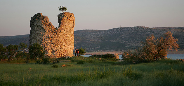
Located at the edge of Večko polje(field), Večka kula(tower) was built by Venetians in 16th century as a part a fortification system that protected Podvelebitski Channel from the Turks. Presumably the tower was attached to the village of Veče (Veche), which was located in the area of modern Seline and was first mentioned by written sources in year 1508. The Romanesque church of St. Peter’s probably belonged to the same village. Aside from the historic information, no trace of the village survives today.
Večka tower was strategically placed at a location from which it was possible to watch the ships passing through Podvelebitski Channel. From here, an important communication route crossed the channel to Vinjerac and continued into the Zadar’s hinterland. Another route led through the Velika Paklenica gorge and across Velebit into the Lika highlands. A fortification at Paklarić, above the entrance to the gorge, testifies of that route’s importance. In the second half of the 17th century, Večki porat is mentioned as the main port for export of lumber cut in Paklenica. The same report also mentions Večka Tower as already deserted and crumbling. The village of Veče probably had disappeared by that time due to Turkish incursions.
Judging by its surviving remains, the tower was surrounded by a rectangular courtyard, nowadays partially inundated by the sea. The interior face of the tower wall is pierced by holes that held wooden floor beams, indicating that the structure had three floors. Narrow embrasures with sharply bevelled sides are still visible on the highest floor.
Many legends have been told about Večka Tower. The best-known among them is the legend of King Pasoglav (“Doghead”):


ARGYRUNTUM
During the last two centuries B.C., Roman legions gradually conquered the eastern Adriatic littoral. Roman province of Dalmatia was finally established at the beginning of the 1st century A.D. It included the surroundings of Starigrad-Paklenica, an area originally inhabited by autochthonous Liburnians.
At that time, the first urban settlement was founded at the location of modern Starigrad-Paklenica. Roman Argyruntum occupied a small peninsula that covered an area of some 3,5 hectares. Due to natural processes of alluviation and recent construction work (building of the coastal highway), this peninsula today fully adjoins the mainland.
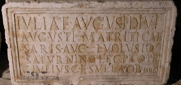
Argyruntum soon became an important market town. Several stone inscriptions, found in what is today St. George’s Street, speak about its early history. According to one of them, in mid-first century A.D., Roman emperor Tiberius provided the town with defensive walls and towers. At that time Argyruntum was probably elevated to municipal status, which meant that its inhabitants attained Roman citizenship.
At the beginning of the 20th century, archaeologists Abramić and Colnago discovered the remains of Roman town walls underneath modern Starigrad. A regular grid of streets probably existed within the town walls. Beyond the walls, along the main road leading towards the southeast, stretched the town cemetery.
The archaeologists excavated some 400 burials of Argyruntum’s cemetery. As was the custom throughout the Roman Empire, people cremated their dead and deposited their ashes in urns made of glass, ceramic or stone. Various objects were put in graves next to the urns. Those objects testify of prosperity and refined tastes of the town dwellers, as well as of trade relations with distant corners of the Empire. Outstanding finds include jewelry made of silver, bronze and amber, oil lamps, tools and weapons, and vessels made of pottery, glass and metal. Rich finds from Argyruntum’s cemetery indicate that, during Roman Imperial times, today’s Starigrad-Paklenica fully enjoyed the splendors of Classical civilization.
Of particular interest is the collection of glass vessels, which contains 146 vessels of various shapes. Some of them were imported from Egypt, Syria, Cyprus, Italy, Pannonia, and the Rhine regions of Gaul, while others were made in local workshops. The collection of Roman glass from Argyruntum is housed at the Museum of Ancient Glass in Zadar (Muzej antičkog stakla).
With the decline of Roman power, Argyruntum lost its commercial importance. Its impoverished inhabitants moved to safer locations on the surrounding slopes of Velebit, where they persisted until the end of Classical civilization.


